Are you ready for the weather bomb? That's a term you've likely heard a lot today as a very powerful storm approaches. So...what the heck is a "weather bomb?" A
weather bomb is the
meteorological term that describes a rapid drop in pressure over a 24 hour period.
Meteorologists measure pressure in millibars and for a storm to be considered a weather bomb a region would need to experience a 24
mb drop in pressure over 24 hours (or 1
mb/hr). So is this storm a "weather bomb?"

To determine in advance if our region will experience such a rapid drop in pressure we need to look at both the leading edge of the storm and the "central pressure" (or the area of lowest pressure). Since these storms generally move from west to east we'll look at the eastern edge of the storm compared to the center. (I grabbed the image above from a forecast model so this is not an actual observation...but it's pretty close to reality). Just ahead of the cold front the the pressure is around 1000
mb compared to a central pressure of 956
mb. That's a 44
mb drop! While I'm not expecting to see a 44
mb drop in pressure in 24 hours, considering just how low the central pressure of this storm is, a 24
mb over 24 hours is very likely. So what does this all mean for
Peterborough and the
Kawarthas? The faster the pressure drops the faster the winds will be. This is a called a pressure gradient. When you go from an area of high pressure to an area of low pressure over very short distance you have what is called a "steep pressure gradient." The steeper the gradient...the faster the wind. Tonight we'll see a very steep gradient leading to sustained winds in excess of 40km/h and gusts in excess of 60 to 80 km/h. High winds with heavy rain and possible thundershowers can be expected this evening all thanks to what is know as a "weather bomb." While we're not talking about a hurricane here...tonight will still be very windy with the potential to be fairly active.

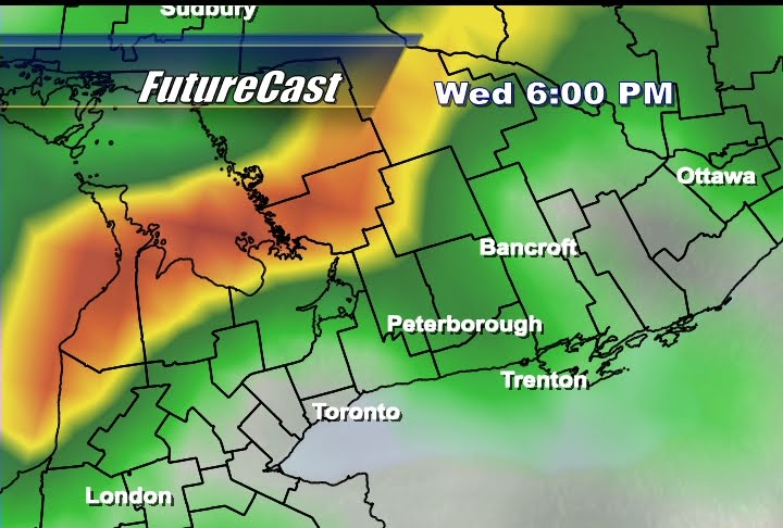
 Some mixed precipitation is possible tonight (maybe some wet snow just north of the city) but we'll likely just see rain tonight as the temperature will be too mild. As you can see in the image above, the latest ADONIS model has the rain/snow line well north of the city. I think the best bet for snow this evening (in our viewing region) would be in Haliburton.


 Here's a pic from Kim


 Here's a


 Our trip started in London two weeks ago when we flew into Gatwick Airport. After a 7 hour flight, we spent the next two hours negotiating London rail (including a busy rush hour tube ride) to King's Cross rail station where we boarded a train to Scotland to spend the next four days with Kate's aunt and uncle...in fact, we stayed with family the entire time. (It pays to have a wife who was born in England). We walked the Royal Mile, toured Edinburgh Castle, saw Abbotsford (the home of Sir Walter Scott), visited a real whiskey distillery, dipped our feet in the North Sea and toured countless other sites. Here's a great pic of our visit to Melrose Abbey...
 Finally, it was back to London for 3 days and two nights at Kate's cousin Oliver's "flat." We walked Millenium Bridge, toured the Tower of London, Tower Bridge, the V&A Museum, Hyde Park and of course we saw Big Ben...

 Between noon and 2pm (as you can see above) this model is calling for some very intense rain with possible thunderstorm activity. Keep in mind this is "future radar" and not an actual radar image that we're looking at here. Purple indicates intense weather on a radar image (anything above 60-65 dBZ for you weather nerds). This can mean very heavy rain, thundershowers and even hail. While I do not expect anything this severe tomorrow (most of that "purple stuff is still west of the city in this image) I do think that 10-20mm of rain could fall in a very short amount of time. While we're not talking about a flood situation with these amounts, some pooling of water on the roads is possible durning the "lunch rush" tomorrow which could make for a hectic commute around town.
 Luckily for us, this system looks to move through the region at a quick pace. By tomorrow evening that "low" should be making its way to the east of our region by 8pm and I expect a clearing trend tomorrow night into Friday. All in all, as much as 25mm of rain is possible...but hopefully rainfall totals end up on the low end as our city's infrastructure is not always "100% effective" on handling a lot of rain in a short amount of time.
 Rolling the ADONIS model ahead a few hours and things look good for the afternoon. An area of high pressure pushes in from the west and cleans things up. By the dinner hour we'll be firmly under the influence of that "high" but a low pressure centre will be on our region's "doorstep" that I expect will bring a few showers into the overnight hours with some rain into Thursday. Also, with the jet stream just south of us, we can expect cooler than normal tempertures to prevail over the next few days.
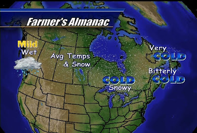 The Farmer's Almanac is calling for "mild and wet" weather for the Yukon, BC and western alberta. They expect "average temperatures and snowfall" for the prairies and north into the territories. Ontario will be "cold and snowy" with "bitterly cold" temperatures heading east through Quebec into New Brunswick and Newfoundland. Good news for folks living in Labrador...you'll only be dealing with "very cold" as opposed to the "bitterly cold" temps for the rest of Atlantic Canada. Snowfall will also be "average" for most of eastern Canada. Whether you believe in the Farmer's Almanac or not...you have to give them credit for trying. Forecasting a year in advance can't be easy, just look at how often my 7 day forecast is...um...less than 100% accurate. Happy Friday!


 In addition to the instability normally associated with a low pressure centre, we're also likely to see some lake enhanced precipitation...similar to lake effect snow (only with rain). With that "low" now sitting to the northeast and an area of high pressure to the southwest, I expect a west/northwesterly flow of wind that will pull in some moisture leeward of Lake Huron and Georgian Bay. Now before you get too down on the weekend, I don't expect a washout. Most of that moisture will not make the trip this far east, so a steady rain isn't likely. Expect a few showers dropping 5-10mm of rain (at most) over both days. Some sunny breaks can also be expected...but it will be a very cool weekend across the region.
 Now let's talk Earl. Our weekend forecast looks "peachy" compared to parts of Atlantic Canada as Earl continues to push north. The latest Canadian Hurricane Centre track (see above) has the storm hitting western Nova Scotia as a Cat 1 Hurricane with wind in excess of 119 km/h Saturday Morning. The storm then impacts P.E.I. before turning north over eastern Quebec and into Labrador.
 The National Hurricane Center (U.S.) has the storm hitting western Nova Scotia as a Tropical Storm (no longer a hurricane). The NHC's track differs with the storm, after hitting the Bay of Fundy and rolling into the Gulf of St. Lawrence, turning east affecting eastern Labrador and western Newfoundland along the Straight of Belle Isle. Either way, this storm looks pretty bad for much of Atlantic Canada. Graham Hart is in Nova Scotia and will join us by phone on Tuesday for a wrap on Hurricane Earl.
 By 8pm the cold front will be well to the east of us but there is still alot of instability to the west of the frontal boundary. That wraparound precipitation will likely occur into Saturday (boo) but it's still only Thursday so don't start planning to hang the weatherman just yet. I will touch on Earl quickly here as he does make quite a dramatic appearence in the above image. This model has that cold front still a good distance away from Earl so any hope of that front either weakening (shear) or deflecting Earl in any way is pretty slim.

 So where will Earl make landfall? You have to take the above image with a grain of salt as we are still days away but the CHC is very concerned that Earl will make a direct hit with Nova Scotia on Saturday. The above image is a composite of various hurricane models and the “cone of uncertainty” has this cyclone landing anywhere from Maine to eastern Nova Scotia as a category 1 hurricane with winds in excess of 119 km/h. Earl will quickly weaken over land but could still affect P.E.I. as a tropical storm or depression with wind speeds ranging from 50-100km/h before bringing heavy rain and high winds to Labrador and western Newfoundland. Why so powerful? You can thank warmer than normal sea surface temperatures around Nova Scotia. Although the water there is no longer warm enough to favour storm development (cooler than 26.5 degrees), it's still warm enough for this storm to maintain hurricane strength for some time.