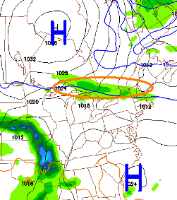
Now that I have your attention...I’ll let you know that there's only a slight chance of snow. First off, let’s talk about the weekend. Looking at the latest GFS run (the pic to the left) it looks like Saturday we’ll see some showers likely by the afternoon and some rain in the evening as that band or rain descends from the north. Some good news is that Sunday looks to be nice at this point for Peterborough. If you live south of the city you may catch a break but don’t hold your breath. Let’s hope that the rain arrives later in the day tomorrow as there is a fundraising yard sale planned to support a remote aboriginal community in the far north in their effort to buy space heaters for school children. It’s a sad story and a great cause so check it out tomorrow at St. Alphonsus Church 1066 Western Avenue (off Clonsilla) from 7am – 3pm. Great deals for a great cause. Check out their group on Facebook for more details.
 So now on to that whole snow thing. Having a look at the latest NAM run, that big low you see in the second pic will be right on top of us Monday into Tuesday and is full of moisture having tapped into both the Gulf and the Atlantic. With temperatures hovering around the freezing mark late Monday through the overnight, we could see some mixing and possibly some wet snow. As the temperature climbs into Tuesday it should switch back to rain (yay) and keep in mind it’s only a chance of wet snow.
In short, I hope you enjoyed today and take advantage of the sunshine on Sunday because we could be seeing some wet weather through the start of next week. Have a great weekend! (Sorry about the rain).

