 Hmmm...what is that white stuff on the hood of that car? Is it dust? Dirt? Dandruff? Nope. It's snow. Lisa tweeted me this pic of her car this morning in Pontypool. It was -1 in Pontypool this morning with light precipitation. The result? Snow. Even though it is still too early to "stick," I always get a few concerned emails from folks who are shocked to see snow this early. As much as it pains me to say it...this isn't early. Snow in October is common for our region and all it takes is a cool, dry northwesterly flow of wind to draw in some moisture from Lake Huron and Georgian Bay. These lake effect snow bands usually stay southwest of Peterborough (as was the case today...although we did see a few flakes) but Pontypool is right in their path when the wind is out of the northwest. Barrie saw over 5cm of accumulation this morning and snow fell as far south as Oshawa. Thanks for sending in this great image Lisa. I plan on saving it so that I can look at in January. While the picture strikes fear in the hearts of Canadians now...this same image will produce a few laughs after a mid-January snowstorm. Love it or hate it...winter is coming.
Friday, October 22, 2010
Do not adjust your monitor.
Hmmm...what is that white stuff on the hood of that car? Is it dust? Dirt? Dandruff? Nope. It's snow. Lisa tweeted me this pic of her car this morning in Pontypool. It was -1 in Pontypool this morning with light precipitation. The result? Snow. Even though it is still too early to "stick," I always get a few concerned emails from folks who are shocked to see snow this early. As much as it pains me to say it...this isn't early. Snow in October is common for our region and all it takes is a cool, dry northwesterly flow of wind to draw in some moisture from Lake Huron and Georgian Bay. These lake effect snow bands usually stay southwest of Peterborough (as was the case today...although we did see a few flakes) but Pontypool is right in their path when the wind is out of the northwest. Barrie saw over 5cm of accumulation this morning and snow fell as far south as Oshawa. Thanks for sending in this great image Lisa. I plan on saving it so that I can look at in January. While the picture strikes fear in the hearts of Canadians now...this same image will produce a few laughs after a mid-January snowstorm. Love it or hate it...winter is coming.Thursday, October 21, 2010
"I'll huff and I'll puff..."

I want to thank Debra from Havelock for sending in the above picture. This is what her temporary garage looked like this morning after a big gust of wind blew through the region shortly before 10pm. These tent-like "car ports" are very durable and are weighed down to endure windy conditions. Last night's windy weather, however, was apparently too much for this shelter (as well as a swing set and some yard furniture) to handle. Debra actually sent me an email last night to ask if a tornado blew through Havelock last night. She described the wind as sounding like a freight train. After looking at some radar imagery from last night and the mess left in her yard this morning, I think that this was likely just a powerful gust of wind, probably in excess of 60-70 km/h. Here in Peterborough we dealt with sustained gusts in excess of 50 km/h yesterday followedby gusts over 40 km/h today. With sustained winds in excess of 30 km/h I would not surprise if a few localized wind gusts exceeded 60 km/h. Last night we were dealing with the passage of a cold front which can draw in some very powerful southwesterly winds and I think the above image is evidence of that. So will we be dealing with more windy weather tomorrow? Well, although still cool, tomorrow looks to be a little breezy...but not nearly as windy as the past two days.
Wednesday, October 20, 2010
Bundle Up!

Well today was a windy day to say the least. Wind gusts in excess of 50 km/h were a common occurrence with sustained winds over 30 km/h. Tomorrow promises to be another windy one but with one BIG difference...wind direction. Today we saw high southwesterly winds ahead of an approaching cold front but after that front passes tonight (bringing showers and possible thundershowers) the wind will shift to a more northwesterly flow. This will push in some cold, arctic air from the north which will cool us down big time. Hopefully you took advantage of today's 14 degree high because tomorrow we'll likely top out at 6 or 7 degrees. Bundle up!
Tuesday, October 19, 2010
Another "Mixed Bag"
 Wow...Mother Nature was really undecided today. We saw a little bit of everything! From showers, to drizzle, to sunshine to clouds then back to showers, etc. This is the kind of weather that allows me to use my favourite "all encompassing" weather term: the "mixed bag." Looking at the above image...I'll get to use it again tomorrow as another low pressure center moves in.
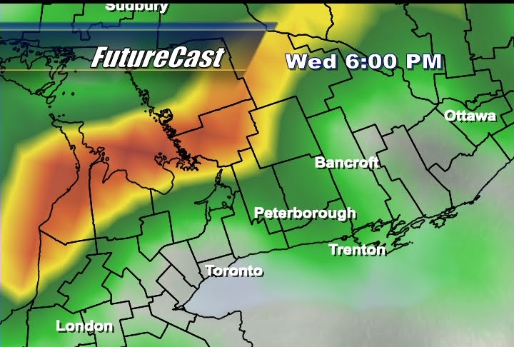 Tomorrow we'll see a partly sunny start to the day before rain as another area of low pressure looks to slide north of the region. A southwesterly flow of wind ahead of a cold front should warm us up to 14 or 15 degrees (seasonal average is 12 btw) but by 6pm (as you can see above) that front will be on our doorstep and we'll likely see showers just ahead of the frontal boundary.
 Some moderate rain can be expected as the front passes tomorrow evening and we may even experience some mild thunderstorm activity. After the front passes we'll be back to generally cloudy conditions with the chance for maybe a shower or two on Thursday. The biggest change, however, will be the temperature. With a more northerly flow of wind expected, Thursday promises to be cool with a high of only 7 or 8 degrees. Be sure to wear a sweater under that rain jacket.
Subscribe to:
Posts (Atom)