 The Farmer's Almanac is calling for "mild and wet" weather for the Yukon, BC and western alberta. They expect "average temperatures and snowfall" for the prairies and north into the territories. Ontario will be "cold and snowy" with "bitterly cold" temperatures heading east through Quebec into New Brunswick and Newfoundland. Good news for folks living in Labrador...you'll only be dealing with "very cold" as opposed to the "bitterly cold" temps for the rest of Atlantic Canada. Snowfall will also be "average" for most of eastern Canada. Whether you believe in the Farmer's Almanac or not...you have to give them credit for trying. Forecasting a year in advance can't be easy, just look at how often my 7 day forecast is...um...less than 100% accurate. Happy Friday!
Friday, September 10, 2010
Looooooooong Range Forecast
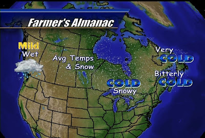
Wow! It's Friday already! I don't know what's better...heading into a long weekend or the short week that follows. In this case, with last weekend's crummy weather, the short work week definitely wins. Today is not just any Friday, today is special. Very special! Today is the day that my job security is put into question. The Famer's Almanac releases there annual forecast today. Annual? How can I compete with that? I only look ahead 7 days and these folks forecast a year in advance. Let's take a look at their winter forecast...The Farmer's Almanac is calling for "mild and wet" weather for the Yukon, BC and western alberta. They expect "average temperatures and snowfall" for the prairies and north into the territories. Ontario will be "cold and snowy" with "bitterly cold" temperatures heading east through Quebec into New Brunswick and Newfoundland. Good news for folks living in Labrador...you'll only be dealing with "very cold" as opposed to the "bitterly cold" temps for the rest of Atlantic Canada. Snowfall will also be "average" for most of eastern Canada. Whether you believe in the Farmer's Almanac or not...you have to give them credit for trying. Forecasting a year in advance can't be easy, just look at how often my 7 day forecast is...um...less than 100% accurate. Happy Friday!
The Farmer's Almanac is calling for "mild and wet" weather for the Yukon, BC and western alberta. They expect "average temperatures and snowfall" for the prairies and north into the territories. Ontario will be "cold and snowy" with "bitterly cold" temperatures heading east through Quebec into New Brunswick and Newfoundland. Good news for folks living in Labrador...you'll only be dealing with "very cold" as opposed to the "bitterly cold" temps for the rest of Atlantic Canada. Snowfall will also be "average" for most of eastern Canada. Whether you believe in the Farmer's Almanac or not...you have to give them credit for trying. Forecasting a year in advance can't be easy, just look at how often my 7 day forecast is...um...less than 100% accurate. Happy Friday!
Wednesday, September 8, 2010
It's not that bad...really!

First off...sorry for the lack of blog posts this week. I was off this Monday for Labour Day and yesterday, um...well I was still recovering from the long weekend. Wet weather aside, I had a great weekend at the cottage and hopefully you made the best of it as well. With the cold and wet long weekend behind us, let's look ahead to this weekend. Looking at the extended forecast above, after another cool and possibly damp one tomorrow, we'll start to clear up nicely for Friday and Saturday and even warm back up to seasonal values. Not bad. As for Sunday...

The above image is from the latest GFS forecast model run. Both the GFS and North American models show some wet weather for Sunday. The North American model has the rain arriving just ahead of a cold front Sunday afternoon but the GFS has that same front arriving later in the day. So will Sunday be a wash out? Well it is only Wednesday but, looking at the latest data, I think a sunny start to the day is possible with increased cloudiness in the afternoon and a few showers by Sunday evening. With temps at least back in the 20's that's not a bad forecast at all even with the rain.
Subscribe to:
Posts (Atom)