
Wow...Mother Nature was really undecided today. We saw a little bit of everything! From showers, to drizzle, to sunshine to clouds then back to showers, etc. This is the kind of weather that allows me to use my favourite "all encompassing" weather term: the "mixed bag." Looking at the above image...I'll get to use it again tomorrow as another low pressure center moves in.

Tomorrow we'll see a partly sunny start to the day before rain as another area of low pressure looks to slide north of the region. A southwesterly flow of wind ahead of a cold front should warm us up to 14 or 15 degrees (seasonal average is 12 btw) but by 6pm (as you can see above) that front will be on our doorstep and we'll likely see showers just ahead of the frontal boundary.

Some moderate rain can be expected as the front passes tomorrow evening and we may even experience some mild thunderstorm activity. After the front passes we'll be back to generally cloudy conditions with the chance for maybe a shower or two on Thursday. The biggest change, however, will be the temperature. With a more northerly flow of wind expected, Thursday promises to be cool with a high of only 7 or 8 degrees. Be sure to wear a sweater under that rain jacket.
 Wow...Mother Nature was really undecided today. We saw a little bit of everything! From showers, to drizzle, to sunshine to clouds then back to showers, etc. This is the kind of weather that allows me to use my favourite "all encompassing" weather term: the "mixed bag." Looking at the above image...I'll get to use it again tomorrow as another low pressure center moves in.
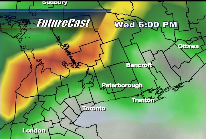 Tomorrow we'll see a partly sunny start to the day before rain as another area of low pressure looks to slide north of the region. A southwesterly flow of wind ahead of a cold front should warm us up to 14 or 15 degrees (seasonal average is 12 btw) but by 6pm (as you can see above) that front will be on our doorstep and we'll likely see showers just ahead of the frontal boundary.
 Some moderate rain can be expected as the front passes tomorrow evening and we may even experience some mild thunderstorm activity. After the front passes we'll be back to generally cloudy conditions with the chance for maybe a shower or two on Thursday. The biggest change, however, will be the temperature. With a more northerly flow of wind expected, Thursday promises to be cool with a high of only 7 or 8 degrees. Be sure to wear a sweater under that rain jacket.
No comments:
Post a Comment