Friday, November 19, 2010

Snow tonight?

Well that "clipper" we were talking about yesterday is continuing to "clip" across Ontario. I'm going to refer to this storm as a clipper even though, unlike most clippers, it's dropping a decent amount of precipitation. Before hitting Northwestern Ontario with snow today, this storm dumped 10-15cm on Southern Manitoba. Residents of Winnipeg woke up to a "winter wonderland" this morning. Well now this storm is moving through Ontario...so are we going to see any snow?
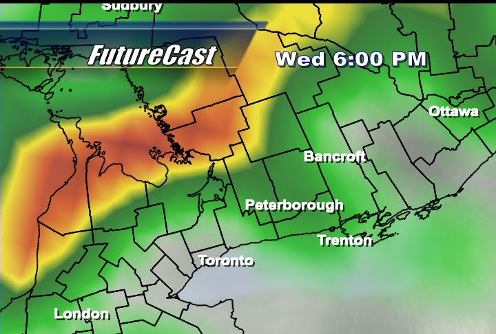
Some mixed precipitation is possible tonight (maybe some wet snow just north of the city) but we'll likely just see rain tonight as the temperature will be too mild. As you can see in the image above, the latest ADONIS model has the rain/snow line well north of the city. I think the best bet for snow this evening (in our viewing region) would be in Haliburton.

Wednesday, November 17, 2010

Windy & Wet

Last night’s soaker was indeed a soaker. Luckily that area of low pressure that brought the rain moved over our region like a bullet. By 10am this morning the rain had mostly tapered off and rainfall totals for our region (with the exception of Oshawa) was on the low end of yesterday’s forecasted values…

• Peterborough (Airport) - 21.7mm
• Peterborough (Downtown Post Office) - 20mm
• Bancroft - 19.3mm*
• Oshawa - 35.4mm

While 20mm here in Peterborough is a lot of rain, Oshawa nearly doubled that. Both of these totals were nothing compared to the rain Kingston saw (my old CKWS TV stomping grounds). K-Town was the clear “winner” with 53.7mm as of 9am this morning when Environment Canada issued a special weather statement with that total. Now that the rain has cleared (yay) it is wind that will be a problem (boo). Gusts in excess of 55km/h have already been recorded at the airport and the wind will continue to shift to a more northwesterly component which will cool things down. Wind was responsible for affecting the Otonabee Transmission Station leaving over 1000 customers without power this afternoon. Power has now been restored (for now) but more outages are possible as high winds continue affect our region this evening.

*Bancroft total as of 9am...rain was still falling there much later.

Monday, November 15, 2010

Movember Update

I think we’ll make this a Monday tradition. Every Monday I’ll give “the ladies” a reason to check out my Weather Blog and today that reason is Tom Selleck. Selleck’s “mo” defined what it meant to be a good looking guy in the 80’s and is a true inspiration for Movember supporters like myself. If only my “stache” looked anywhere close to that. I thought I’d throw up another blog on the “mo” to say thanks to everyone that has made a contribution.

• Mary Reynolds - $25.00
• Donna Sally - $20.00
• Murray Barton - $25.00
• Brian Lainey - $5.00
• Bob &Patti (Bydandacres Kennels) - $100.00
• Bill Brueschy - $50.00
• Beth Smith - $25.00

THANK YOU to everyone that has donated thus far! All of the money raised will help support Prostrate Cancer research so please keep the donations coming in. If you’d like to help out, click here to donate to my Mo-Space page with a valid credit card. You can also drop off a cash donation at our studios (743 Monaghan Rd) during regular business hours. Thanks again and check back next Monday for a list of the latest donors and another “drool worthy” moustache picture.

Friday, November 12, 2010

What a week!

What a week! This has been an incredible week in terms of weather (or lack thereof) with warm and sunny conditions across the Kawarthas. Our 30 year seasonal average this time of year in Peterborough is between 6 and 7 degrees for a daytime high. How warm has it been?

• Monday, 10.1
• Tuesday, 11.3
• Wednesday, 11.2
• Thursday, 11.5
• Friday, 15 degrees!!!!!!!

While 15 degrees is far from a record (current record stands at 18.9 degrees in 1927) 15 degrees Celsius is still a great way to put wrap on an amazing week weather wise. So when will this streak of great weather come to an end? Likely on Sunday…


Looking at the latest NAM run (above), after another warm and sunny day tomorrow that area of High pressure exits allowing that frontal boundary just west of us to move in on Sunday. The passage of a cold front Sunday will likely bring showers followed by cooler weather heading into next week. Sadly...all good things must come to an end. At least tomorrow looks promising. Have a great Saturday!!!

Wednesday, November 10, 2010

Remembrance Day


I love when our veterans get the good weather they deserve for Remebrance Day. November can be very "hit or miss" when it comes to the weather and November 11th is always a gamble. As a reservist (first with the communications reserve and now with the cadet program) I've taken part in countless Remembrance Day ceremonies and have witnessed our veterans deal with both the best and the worst that Mother Nature has to offer. The fact of the matter is this...a large number of our veterans are getting old. The brave men and women who served in World War 2 and the Korean War are getting on in years and bad weather can be very bad for their health. A large number of our veterans literally risk their health to attend Remembrance Day ceremonies across Canada and they, more than anyone, deserve a great forecast so that they can be honoured on November 11th. Tomorrow looks to be very nice for our veterans, our service men and women and our cadets. Although I expect a chilly start to the day, by 10am the temperature should be around 4 degrees with lots of sunshine. For those planning on attending Remembrance Day lunches or dinners the afternoon and evening looks even better. As an area of low pressure approaches (see image above) we'll start to see a more southerly component to the wind which will only help to keep things mild. With great weather expected please take advantage of the mild weather and visit your local cenotaph to pay respect to those who have served. If you plan on attending the Peterborough ceremony...I'll see you there!

Monday, November 8, 2010

The "Mo" is Back!

When one thinks of a moustache the image of Burt Reynolds often comes to mind. Looking at the image above it's hard to believe that the moustache is now a rarity when it comes to male sex symbols. Burt offered the ladies something the likes George Clooney, Robert Pattinson and Tom Cruise all lack...a great "duster." Admittedly, I've been "on the fence" about taking part in this year's Movember fundraiser. I thought "the mo" simply wasn't a good look for me. Apparently I was wrong. I should never have doubted the sheer power of "the stache" as the outpouring of people (namely women) who have been voicing their concern over my lack of facial hair this month has become too large to ignore. Well ladies, I have good news...I'm back on the wagon. I'm growing a "mo" and I need your support. Nearly 25, 000 men will be diagnosed with Prostate Cancer this year and over 4, 000 will die. That's a lot of "mo's." Let's "save the males" but raising some dollars this "Movember." Click here to donate to the cause and let's help the Peterborough Lakefield "Molice" change the face of mens health.
Add Image

Thursday, November 4, 2010

Rain today, snow tomorrow...really?

If you've been watching the "Newswatch Weather Updates" today on CHEX TV you probably already know about that "chance of a few flurries" tomorrow evening. (Sorry to be the bearer of bad news btw). With the wind switching to a more northerly direction tomorrow (thanks to a powerful coastal storm) it will certainly be cold enough for snow as the temp drops from around 3 degrees in the morning to minus 3 tomorrow night. While the evening temperature is more favourable for a few flakes I thought I'd show you what our "FutureCast" expects tomorrow morning. That blue stuff...well that's snow. Our ADONIS forecast model has Peterborough sitting right on the rain snow line early tomorrow morning. So will we actually see snow? That all depends on the temperature. If we are indeed sitting at 3 or 4 degrees tomorrow morning what we'll likely get is just a few rain showers with some possible mixed precipitation (a few flakes mixed in with some rain) but if we're even slightly below the expected overnight low, then a few flurries are possible. What ends up falling depends on just how cold it gets tonight. As for my call, I'd put my money on a few rain showers throughout the day changing to flurries tomorrow night. I wouldn't put a lot of money on though as we're right on the threshold for either rain or snow. As for Haliburton, Bancroft and communities to the north...I think you will see a few flurries starting tomorrow morning and continuing throughout the day.

Wednesday, November 3, 2010

Now that's more like it!

10 degrees! 10!!! As the title of the blog says: "now that's more like it!" We started out the day at -7 and, thanks to a southerly push of warm air ahead of an approaching cold front (see the image above) we gained 17 degrees by 2pm. Even though this frontal passage will also bring a few showers to the region, the cloud cover will at least trap in some of that heat we gained today resulting in a very mild overnight across the Kawarthas. How mild? We'll likely hover around the freezing mark tonight (hopefully above it) which is a heck of a lot better than the -7 we "enjoyed" last night.

Friday, October 29, 2010

Happy Halloween!

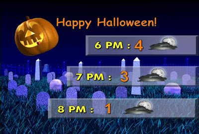
I thought I'd do something a little different tonight on Newswatch...seeing as how it's the Halloween weekend and all. Instead of a "9-2-5 Forecast" I thought I'd breakdown Halloween night and what you can expect on Sunday. Above is my "Trick-Or-Treat" forecast to let you know just what to expect while your escorting the kids around town Sunday night. The conditions look pretty nice (partly cloudy) but it will be on the cool side so be sure to put a jacket under their costume. Oh...and I recieved more Halloween pet pics by the way so here's one more...
The pic above comes from Melissa showing off her Sheltie named Douglas. Doglas is dressed as Captain "Doug" Sparrow from the Pirates movies. The ladies may disagree but I think "Captain Doug" gives Johnny Depp a run for his money. Happy Halloween!

Thursday, October 28, 2010

As Promised...

I made a promise this week to show off a few of your Halloween pictures on CHEX TV and on the blog. Every holiday I ask for fun pictures and the ones I get always seem to have one thing in common...pets in costumes! It never fails, but that's okay. I'm an animal lover to! So, as promised, here are a few Halloween pet pictures that have made their way into my inbox...you may even see a few of these on CHEX.
This first pic comes from Chimo and no that's not just any ordinary skunk! It's the scary "Skunk Shih Tzu" that patrols his property every Halloween.
This next picture showcases a few "Halloween Pugs" courtesy of Kerri, one of our loyal CHEX viewers.

Here's a pic from Kim MacMillan of her cat Jeffery ready to celebrate Halloween. Hmmm...I wonder if he plays Quidditch? Please keep sending your pictures to me at jscotland@chextv.com and I'll show as many of them as I can on TV or here on the blog. I also have a special Halloween forecast for you tomorrow (both online and on Newswatch) that will breakdown what kind of weather you can expect while you're out with the kiddies on Halloween night. Think of it as a "9-2-5" forecast for the 6pm-9pm hours for Sunday night. Check back here tomorrow for your special Halloween forecast!

Tuesday, October 26, 2010

"Weather Bomb"

Are you ready for the weather bomb? That's a term you've likely heard a lot today as a very powerful storm approaches. So...what the heck is a "weather bomb?" A weather bomb is the meteorological term that describes a rapid drop in pressure over a 24 hour period. Meteorologists measure pressure in millibars and for a storm to be considered a weather bomb a region would need to experience a 24mb drop in pressure over 24 hours (or 1mb/hr). So is this storm a "weather bomb?"

To determine in advance if our region will experience such a rapid drop in pressure we need to look at both the leading edge of the storm and the "central pressure" (or the area of lowest pressure). Since these storms generally move from west to east we'll look at the eastern edge of the storm compared to the center. (I grabbed the image above from a forecast model so this is not an actual observation...but it's pretty close to reality). Just ahead of the cold front the the pressure is around 1000mb compared to a central pressure of 956mb. That's a 44mb drop! While I'm not expecting to see a 44mb drop in pressure in 24 hours, considering just how low the central pressure of this storm is, a 24mb over 24 hours is very likely. So what does this all mean for Peterborough and the Kawarthas? The faster the pressure drops the faster the winds will be. This is a called a pressure gradient. When you go from an area of high pressure to an area of low pressure over very short distance you have what is called a "steep pressure gradient." The steeper the gradient...the faster the wind. Tonight we'll see a very steep gradient leading to sustained winds in excess of 40km/h and gusts in excess of 60 to 80 km/h. High winds with heavy rain and possible thundershowers can be expected this evening all thanks to what is know as a "weather bomb." While we're not talking about a hurricane here...tonight will still be very windy with the potential to be fairly active.

Monday, October 25, 2010

Go fly a kite!

Please ignore the title of this blog. That was my lame attempt at humour...tomorrow will not be a very good day for kite flying. High winds will likely lead to the kite "flying you" and, with a good chance of some late day thunderstorm activity, electrocution is another possibility. So just how windy is it going to be? Looking at the latest forecast models (see above), sustained winds ahead of that system will likely be in the range of 20-30km/h and if that's not enough for you...

Just wait! As the day progresses (and the "low"approaches) the wind will continue to pick up speed and switch from a a southeasterly to a more southerly direction. This southerly push of wind, just ahead of a cold front, could see gusts in excess of 60 to 70km/h. Some localized wind gusts, depending on topography, may even be in excess of that. As you can see in the image above (from our CHEX TV ADONIS forecast model) by 8pm we can expect very blustery conditions and rain. Later in the evening, as the cold front passes, a thunderstorm is possible before the wind changes to a westerly direction and begins to "die down" through the overnight hours. So what does this mean for our region? After a somewhat sunny start to the day I expect the clouds to build and the wind to pick up during the afternoon. I then expect a wet and windy evening with possible thundershowers. A few Power outages are possible and a big clean-up is ahead for our local political candidates. Today is election day but if the municipal candidates procrastinate in collecting their election signs...well that wind will leave quite a mess to clean up on Wednesday morning.

Friday, October 22, 2010

Do not adjust your monitor.

Hmmm...what is that white stuff on the hood of that car? Is it dust? Dirt? Dandruff? Nope. It's snow. Lisa tweeted me this pic of her car this morning in Pontypool. It was -1 in Pontypool this morning with light precipitation. The result? Snow. Even though it is still too early to "stick," I always get a few concerned emails from folks who are shocked to see snow this early. As much as it pains me to say it...this isn't early. Snow in October is common for our region and all it takes is a cool, dry northwesterly flow of wind to draw in some moisture from Lake Huron and Georgian Bay. These lake effect snow bands usually stay southwest of Peterborough (as was the case today...although we did see a few flakes) but Pontypool is right in their path when the wind is out of the northwest. Barrie saw over 5cm of accumulation this morning and snow fell as far south as Oshawa. Thanks for sending in this great image Lisa. I plan on saving it so that I can look at in January. While the picture strikes fear in the hearts of Canadians now...this same image will produce a few laughs after a mid-January snowstorm. Love it or hate it...winter is coming.

Thursday, October 21, 2010

"I'll huff and I'll puff..."

I want to thank Debra from Havelock for sending in the above picture. This is what her temporary garage looked like this morning after a big gust of wind blew through the region shortly before 10pm. These tent-like "car ports" are very durable and are weighed down to endure windy conditions. Last night's windy weather, however, was apparently too much for this shelter (as well as a swing set and some yard furniture) to handle. Debra actually sent me an email last night to ask if a tornado blew through Havelock last night. She described the wind as sounding like a freight train. After looking at some radar imagery from last night and the mess left in her yard this morning, I think that this was likely just a powerful gust of wind, probably in excess of 60-70 km/h. Here in Peterborough we dealt with sustained gusts in excess of 50 km/h yesterday followedby gusts over 40 km/h today. With sustained winds in excess of 30 km/h I would not surprise if a few localized wind gusts exceeded 60 km/h. Last night we were dealing with the passage of a cold front which can draw in some very powerful southwesterly winds and I think the above image is evidence of that. So will we be dealing with more windy weather tomorrow? Well, although still cool, tomorrow looks to be a little breezy...but not nearly as windy as the past two days.

Wednesday, October 20, 2010

Bundle Up!

Well today was a windy day to say the least. Wind gusts in excess of 50 km/h were a common occurrence with sustained winds over 30 km/h. Tomorrow promises to be another windy one but with one BIG difference...wind direction. Today we saw high southwesterly winds ahead of an approaching cold front but after that front passes tonight (bringing showers and possible thundershowers) the wind will shift to a more northwesterly flow. This will push in some cold, arctic air from the north which will cool us down big time. Hopefully you took advantage of today's 14 degree high because tomorrow we'll likely top out at 6 or 7 degrees. Bundle up!

Tuesday, October 19, 2010

Another "Mixed Bag"

Wow...Mother Nature was really undecided today. We saw a little bit of everything! From showers, to drizzle, to sunshine to clouds then back to showers, etc. This is the kind of weather that allows me to use my favourite "all encompassing" weather term: the "mixed bag." Looking at the above image...I'll get to use it again tomorrow as another low pressure center moves in.

Tomorrow we'll see a partly sunny start to the day before rain as another area of low pressure looks to slide north of the region. A southwesterly flow of wind ahead of a cold front should warm us up to 14 or 15 degrees (seasonal average is 12 btw) but by 6pm (as you can see above) that front will be on our doorstep and we'll likely see showers just ahead of the frontal boundary.

Some moderate rain can be expected as the front passes tomorrow evening and we may even experience some mild thunderstorm activity. After the front passes we'll be back to generally cloudy conditions with the chance for maybe a shower or two on Thursday. The biggest change, however, will be the temperature. With a more northerly flow of wind expected, Thursday promises to be cool with a high of only 7 or 8 degrees. Be sure to wear a sweater under that rain jacket.

Friday, October 15, 2010

Nicer weather ahead...I promise.

Today was another "messy" weather day but it wasn't rain that had folks complaining (like yesterday)...it was the wind. Looking at the GFS image above you can see just how windy it was today. Pinched between an area of high pressure to the west and that Nor'Easter to the east we dealt with wind gusts nearing 50 km/h. Over this "messy" two day stretch we've dealt with cold, blustery winds and over 20mm of rain. Are you tired of the wind and rain yet? Good news, that low continues to move east and an area of high pressure should make for a nice one tomorrow...

Here's a GFS shot for tomorrow (I've removed the wind barbs so it looks less jumbled). As you can see, that Nor'Easter is well out of our region and we look to be firmly under the influence of high pressure. While it promises to be sunny and calm across the Kawarthas, Atlantic Canada will still be dealing with that powerful low which will bring over 40mm of rain to some communities and pack sustained winds of 40-50km/h with gusts as high as 80km/h! So while the last two days may have seemed miserable here in Peterborough...just think of our friends to the east and what they'll be dealing with tonight and tomorrow. As for that cold front just west of us tomorrow (above image), I'm not too concerned. It may result in some cloudier conditions than we'd like to see on a Sunday and a little rain (if any) but, on the whole, the weekend is looking pretty good.

Wednesday, October 13, 2010

"All good things..."

Hopefully you enjoyed today's sunny start as the day looks to wrap up in a very different fashion. This morning, although chilly at -3 degrees, saw yet another sunny start...something we've seen a lot of lately. The Thanksgiving long weekend was incredible weather wise and this morning's sunshine was a great way to cap off a very nice stretch of weather. Unfortunately all good things must come to an end. As you can see from the latest NAM run (above), that area of high pressure responsible for the recent sunshine is making an exit today. Cloud cover continues to develop ahead of that front even as I write this blog. This front will likely result in overcast conditions and a few showers this evening. Ironically, the cloud cover this "cold" front is responsible for will at least give us a much more mild overnight low. A nice layer of cloud cover is like throwing a thick blanket on the bed as it literally traps in the heat gained during the day. Tonight's low of +6 degrees is at least one silver lining to the wet weather ahead over the next few days.

Friday, October 8, 2010

Giving thanks to Ma' Nature!

If the higher prices at the pumps or the extra police cruisers on our roads didn't already tip you off...this weekend is indeed a long weekend. So how about the weather? Thanksgiving weekend is always a gamble when it comes to the weather simply because fall is a transitional season. During fall, warm air is in a constant battle with the cold polar air that is advancing from the north. The weather changes dramatically with every swing of the jet stream...but that doesn't look to be the case this long weekend. Looking at the latest NAM forecast model run above, the weather this weekend will be "brought to you by the "etter H" as a nice, stable area of high pressure settles in for a few days. So how long will this "high" stick around?
Likely for the entire long weekend and beyond. As you can see above, I'm not forecasting any rain until next Wednesay, although Thanksgiving Monday could be a bit cloudy at times, I expect lots of sunshine for two of the three days. Aside from a chilly overnight (-2 degrees) Saturday into Sunday, the weekend is looking almost perfect! On behalf of everyone here at CHEX I wish you all the best this Thanksgiving. Let's all enjoy a safe and happy holiday!