Wednesday, June 30, 2010

Mother Nature Loves Canada!


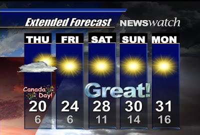
I just had to throw this up on the blog as I couldn't wait until 6:30pm. Like a proud parent flaunting pictures of their kids, I just wanted to brag about the amzing weekend forecast. Whenever you see an "extended" or "long range" forecast, you have to take it with a grain of salt. (Especially the 7 Day Forecast). Mother Nature can always throw a curve ball but all of the forecast models seem to be in agreement about the weekend...and it looks great. Our own CHEX FutureCast shows the potential for a few more cloudy periods than we'd like to see tomorrow afternoon for Canada Day but, after a cool one tomorrow (and VERY cool tomorrow night), we warm up for Friday and Saturday and Sunday should be sunny and HOT. Although cool, Canada Day also scores a passing grade. So enjoy the time off tomorrow, the great weather and, on behalf of the CHEX team...Happy Canada Day!

A Wild One!

As promised here are those pictures I mentioned on Newswatch yesterday from Monday's late afternoon storm. The high that day was near 30, the dewpoint was 22 degrees and with the humidex it felt 35-37 degrees. Whenever you have heat and abundent moisture (humidity) you have two of the three ingredients needed for severe weather. The last ingredient is a triggering mechanism and a weak cold front (in this case a trough) did push througAdd Imageh the region and the result (in this case high winds and heavy rain) can be seen below.


The first two pics are from Norwood, the third is from Cavan (frightening cloud development) and the final image is from Havelock. Thanks to Katie, Jeff, Devon and an anomymous photographer for sending these images. Remember, you can always email me your pics to jscotland@chextv.com and I'll try feature them on CHEX Newswatch or here on the blog.

Monday, June 28, 2010

Whew!


Although folks living near the Texas/Mexico border will be unhappy, many are breathing a sigh of relief along the gulf coast. Hurricanes can be devastating enough to coastal communities on their own let alone combining a super storm with one of the largest environmental disasters in history. This scenario is almost unimaginable and luckily this looks to be NOT the case with "Alex." Tropical Storm Alex is expected to develop into a category 2 hurricane as it moves over the warm waters of the Gulf of Mexico. The good news is that the latest track (seen above) puts that storm well to the west of that giant oil slick from the Horizon deep water leak. (Please keep in mind that my oil slick drawing is a VERY rough estimate and not to scale). Even if the storm strays to the very edges of the Hurrican Center's cone of error...it is still likely to miss the oil. That's the good news. The bad news? This is only the start of the Atlantic hurricane season and more storms are likely to affect the gulf over the next few months.