 When I mentioned today that we could see some rain on Saturday...well...it didn't go over to well here in the newsroom. But really, it's not all that bad. We need the rain. Big time. We have seen a lot of dry and sunny weather over the last week and with relative humidity in the low 20% range, the threat of grass or brush fires is high. Very high. Yesterday we had some video for you of a grass fire on Pigeon Lake Road and today I had the chance to see first hand the damage caused by a big fire on Television Hill (the former site of CHEX TV). The OPP are investigating that fire as it's suspicious. So rain is welcome thing.
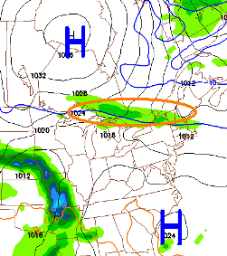
Now on to the forecast for Saturday. To the left is a shot of the latest run of the NAM forecast model for Saturday evening. A ridge of high pressure splits that complex system and really keeps the bulk of activity out of the region. The bottom end of this series of lows slides southeast and will likely be a big rain maker for the Carolinas, but some showers are possible here in Peterborough late in the day on Saturday from the northern portion of that system. The current run shows us getting clipped by that band of rain (highlighted in the pic) on the backside of a low, the same low that could bring showers to Haliburton and Bancroft as early as tomorrow night. The good news is that the front passes quickly and should clear into Sunday.
The further north you live the more likely you are to see rain on Saturday. Here in Peterborough, you can expect to see more cloud than sun with showers late in the day and if you live in the Durham region, things look to be nice with a mix of sun and cloud. I'll keep you posted if there are any changes...good or bad.
Oh...and if you have any info on that grass fire on Television Hill, please call the OPP or Crimestoppers.
No comments:
Post a Comment